Why Land Pooling Leaves Kochi’s Landowners Wealthier Than a Cash Buyout
- Aadarsh k s
- Aug 22
- 9 min read

Read this if: you own land across the 20 notified revenue villages of the Kochi Outer Ring Road (ORR), or want to understand how Kerala can assemble 6,000 acres of high-density metropolitan infrastructure without bankrupting the state treasury or displacing its citizens.
Key Facts:
Parameter | Detail |
The Cadastral Challenge | Average operational holding in Ernakulam is 0.18 hectares (44 cents); 96.7% of holdings are marginal (<1 ha). |
Conventional Buyout Cost | Acquiring the 5,100–6,400 acre ancillary growth ribbon in cash under RFCTLARR-2013 would cost ₹9,000–14,000 Crore - fiscally impossible for Kerala. |
The Land Pooling Alternative | Landowners contribute raw parcels and receive 30%–40% developed, serviced land in high-density TOD nodes + 10%–15% tradeable REIT units. |
Statutory Floor-Price Guarantee | Landowners hold a legal put option to exit for 100% LARR-calculated cash compensation at any point prior to physical plot handover. |
Treasury Cash Savings | Reduces state cash outlay from ₹2,067.24 Crore to ₹520 Crore, saving ₹1,547.24 Crore in direct cash. |
10-Year Wealth Multiplier | Projected landholder asset value reaches 2–3× LARR cash compensation within a decade. |

In Kerala, whenever a revenue official arrives with a survey tripod, landowners prepare for a generational confrontation.
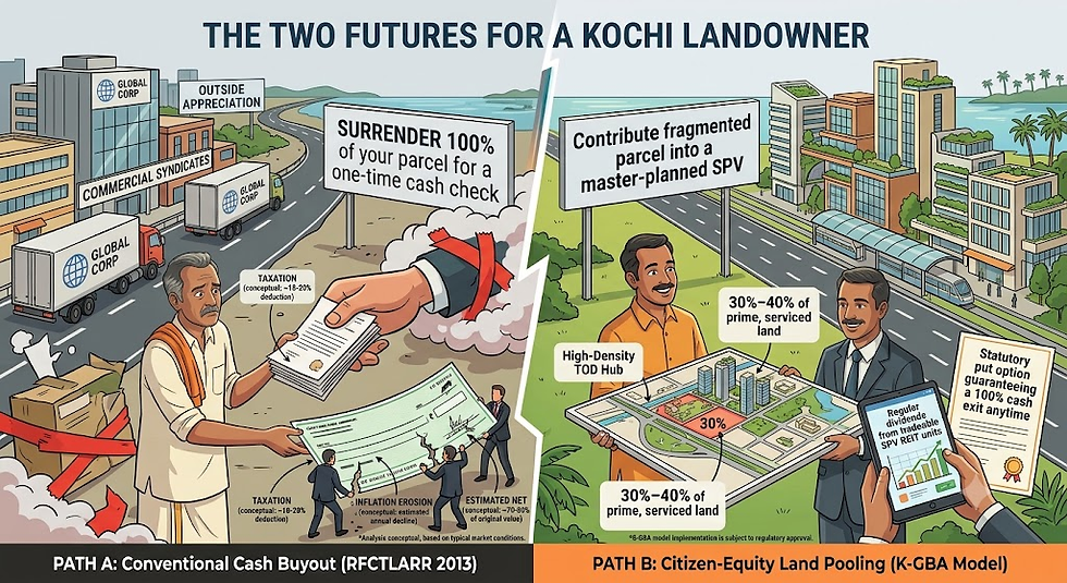
Decades of linear infrastructure history across the state have conditioned citizens to expect an adversarial binary: either a protracted legal dispute over outdated fair-value registries, or a one-time government cash payout that quickly depreciates against inflation, capital gains taxation, and legal fees while outside commercial developers reap the windfall appreciation generated by the new corridor.
With the Section 3(a) notification under the National Highways Act, 1956 now active for the ₹6,935.60 Crore Kochi Outer Ring Road (ORR), over 20,000 property owners across 20 revenue villages in Ernakulam and Alappuzha are confronting this exact choice.
Compulsory cash acquisition is structurally broken for metropolitan-scale land assembly. There is a statutory alternative that transforms landowners from displaced antagonists into permanent equity partners in the city they help build.
1. The Cadastral Reality: Why RFCTLARR 2013 Fails in Ernakulam's 44-Cent Fabric
The Right to Fair Compensation and Transparency in Land Acquisition, Rehabilitation and Resettlement Act, 2013 (RFCTLARR) was engineered for linear rights-of-way-such as highway alignments and railway tracks. It fails when applied to large-format, non-linear urban agglomerations like logistics hubs, dry ports, and technology clusters.
In Ernakulam district, the average operational landholding is just 0.18 hectares - exactly 44 cents. A massive 96.7% of all operational landholdings are classified as marginal (<1 hectare).
This extreme fragmentation is the direct structural result of the First Kerala Model’s land reforms: generational partition across three generations combined with the homestead (purayidam) settlement pattern, where houses are distributed across the landscape rather than clustered in dense village cores.

This fragmentation produces two structural bottlenecks:
For the State Exchequer: Assembling a single 100-acre contiguous industrial plot requires negotiating, executing title searches, and issuing awards to between 220 and 280 distinct landowning interests. If even 2% of owners initiate litigation under Section 64 of the LARR Act, entire construction packages stall for years.
For the Landowner: A 44-cent parcel is too small to generate an agricultural livelihood, but it represents the family's primary store of intergenerational wealth and price optionality. When the state offers a one-time cash buyout based on lagging government fair-value benchmarks, the economically rational response is to resist, litigate, or hold out for higher compensation.
If the state attempts a traditional cash buyout for the 5,100 to 6,400 acres of ancillary development land required along the 5-km ORR ribbon, the exchequer would need to fund ₹9,000 to ₹14,000 Crore in land compensation alone.
With committed expenditures (salaries, pensions, interest) consuming over 77% of Kerala's total revenue receipts and discretionary capital expenditure running at roughly 1.34% of GSDP, the cash buyout route is arithmetically impossible.
2. The Micro-Zone Valuation Arbitrage: The Root of Litigation
Land acquisition litigation in Kerala is driven by the structural gap between government fair-value registries and real market transactions. Across the 20 notified revenue villages of the ORR corridor, fair values systematically lag actual open-market rates by 42% to 50%:
Micro-Zone & Geography | Segment Alignment | Government Fair Value | Actual Market Transaction Rate | Fair-Value Lag | Core Acquisition Footprint |
Zone A: Southern Terminus (Aroor, Kumbalam, Thekkumbhagam) | Segment 5 | ₹1.60–2.20 Cr/acre | ₹2.80–4.50 Cr/acre | 43%–49% | ~120 acres |
Zone B: Eastern Suburbs (Thiruvankulam, Kureekkad, Maradu) | Segment 4 | ₹1.40–1.90 Cr/acre | ₹2.40–3.80 Cr/acre | 42%–50% | ~140 acres |
Zone C: Industrial Belt & Plateau (Perumbavoor, Puthencruz) | Segments 2–3 | ₹0.45–0.75 Cr/acre | ₹0.80–1.40 Cr/acre | 44%–46% | ~380 acres |
Zone D: Northern Gateway (Angamaly, Karukutty, Mattoor) | Segment 1 | ₹0.70–1.10 Cr/acre | ₹1.20–2.00 Cr/acre | 42%–45% | ~259 acres |
Under RFCTLARR 2013, statutory solatium is calculated on outdated base fair values. Landowners know their property is worth significantly more in open-market transactions, which inevitably triggers court references and stay orders.
Land pooling completely eliminates this arbitrage: instead of debating past baseline land values, landowners receive reconstituted, fully serviced plots whose value is determined directly by the new, high-density commercial market created by the corridor.

3. The Citizen-Equity Land Pooling Architecture
Under the proposed Kerala Town Planning (Citizen-Equity Land Pooling) Act-an enhancement of the existing Kerala Town and Country Planning Act, 2016-landowners do not sell their land to the state. Instead, they contribute raw, fragmented, and unserviced plots into a statutory Special Purpose Vehicle: the Kochi Growth Belt Authority .
Drawing on proven national benchmarks like the Gujarat Town Planning and Urban Development Act, 1976 and the APCRDA Scheme, 2014, the SPV consolidates the land, master-plans the sector, installs trunk infrastructure (4-lane access roads, underground power cabling, water mains, fiber conduits, and flood-resilient drainage swales), and returns a reconstituted, fully serviced parcel directly to the original owner.

The Equity Conversion Matrix
Every enrolled landowner receives a two-part consideration: serviced, high-value urban land located inside a master-planned Transit-Oriented Development (TOD) node, plus dematerialised, dividend-bearing REIT securities:
Contributed Parcel Class | Serviced Land Returned (Relocated into high-value TOD grid) | SPV Equity / REIT Units (% of contributed fair value) | Economic Outcome for Landowner |
Small Commercial Fragment (1–2 acres) | 40% | 12% | Re-allotted in node commercial cores; captures immediate, high-value retail and office footfall. |
Medium Fallow/Agri Cluster (5–10 acres) | 35% | 10% | Volume tier; re-allotted in mixed-use residential/commercial rings; ideal for apartment development or lease yield. |
Large Estate Tract (10–20+ acres) | 30% | 15% | Maximizes liquid, dividend-yielding securities for family trusts, plantations, and institutional holdings. |
Dwelling-Standing Parcel (Homestead) | 40% + Guaranteed Housing Plot | 10% | Physical vacation is sequenced strictly after replacement housing is delivered, backed by a transitional living allowance. |
The securities leg is issued by a SEBI-regulated SPV subsidiary. Units are tradeable after a 3-year lock-in, heritable, pledgeable for collateral at local cooperative banks, and pay annual cash dividends generated from corridor land leases, node ground rents, and premium FSI sales.
4. The Aikaranad Mathematical Proof: 10-Year Wealth Comparison
To evaluate why land pooling leaves the landowner substantially wealthier than a conventional cash buyout, consider a concrete worked example from Segment 3 (Eastern Plateau):
The Scenario: A family in Aikaranad contributes 6.0 acres of fallow garden land. The government fair-value benchmark is ₹0.55 Crore per acre (Total Contributed Fair Value = ₹3.30 Crore).

Path A: The Conventional LARR-2013 Cash Award
Base Fair Value: 6.0 acres × ₹0.55 Cr/acre = ₹3.30 Crore.
Solatium & Multipliers: Applying standard 100% solatium produces a gross one-time payment of ₹6.60 Crore.
Long-Term Outcome: After accounting for capital gains tax, inflation erosion, and reinvestment friction, the capital base steadily depreciates. The family no longer owns property along the corridor.
Path B: The Citizen-Equity Land Pooling Model
Serviced Land Returned (35%): The family receives 2.1 acres of fully developed commercial land situated within the master-planned Puthencruz TOD Node.
Securities Allocation (10%): The family receives ₹33 Lakh in tradeable SPV REIT units.
10-Year Valuation (2035 Horizon): With the 8-lane expressway operational and the Free Trade Warehousing Zone (FTWZ) active, fully serviced commercial land inside the Puthencruz TOD node is conservatively projected to trade at ₹6.0 to ₹9.0 Crore per acre.
Net Land Asset Value: 2.1 acres × ₹6.0–9.0 Cr/acre = ₹12.60 to ₹18.90 Crore.
Securities Dividend Yield: The ₹33 Lakh REIT portfolio generates a regular 6% to 8% annual dividend (₹2.0 to ₹2.6 Lakh/year in passive cash income).
$$\text{Total 10-Year Family Wealth} = ₹12.60\text{ to }₹18.90\text{ Cr (Land)} + ₹0.33\text{ Cr (REIT)} = \mathbf{₹12.93\text{ to }₹19.23\text{ Crore}}$$
By participating in land pooling, the family captures 2 to 3 times the wealth of a cash buyout, retains prime real estate, and receives perpetual passive dividend income.
5. The Statutory Safety Net: A 100% Floor-Price Put Option
The primary objection raised by landowners in infrastructure corridors is risk: "What happens if project execution is delayed or commercial demand drops?"
To remove downside risk, the Land Pooling Act establishes a Statutory Floor-Price Put Option:
The Guarantee: Every enrolled landowner holds an unconditional, legally binding put option to exit the scheme for 100% of their calculated LARR cash compensation (fair value plus full 100% solatium) at any point prior to the physical handover of their serviced return plot.
If the metropolitan corridor booms as projected, the landowner retains their appreciating serviced plots and REIT shares. If market conditions deteriorate, the owner exercises the put option and receives full cash compensation.
This single clause turns land pooling from an uncertain speculation into a floor-protected investment with un-capped upside.
6. The Spatial Conservation Proof: How Vertical Density Protects 85% of Wetlands
Beyond household wealth, land pooling provides a structural solution to Kerala’s environmental challenge: absorbing metropolitan economic growth without paving over floodplains, paddy lands, and backwaters.
Over the 2026–2047 build-out cycle, Greater Kochi will require an estimated 300 to 380 million square feet of new commercial, industrial, logistics, and residential floor space.

The Sprawl Scenario (Status Quo): If delivered horizontally under Kerala’s prevailing effective Floor Space Index (FSI) of 0.6 to 1.0, this floor space demand will consume 9,000 to 13,000 acres of greenfield land. Ribbon sprawl will encroach on lowlands, destroy natural drainage channels, and exacerbate monsoon flooding.
The Vertical TOD Scenario (K-GBA Blueprint): By designating high-density TOD nodes carrying FSI 8.0x to 10.0x within a 1.5-km radius of the 4 major interchange hubs (Mattoor, Puthencruz, Thrippunithura, and Aroor), the entire 380-million-sq-ft demand is absorbed within compact, transit-oriented clusters.
$$\text{Horizontal Sprawl Footprint} = \frac{380,000,000\text{ sq ft}}{43,560 \times 0.8\text{ FSI}} \approx \mathbf{10,900\text{ Acres}}$$
$$\text{Vertical TOD Footprint} = \frac{380,000,000\text{ sq ft}}{43,560 \times 9.0\text{ FSI}} \approx \mathbf{970\text{ Net Acres}}$$
Net result: more than 85% of the surrounding agricultural land, paddy wetlands, and water channels across the 5-km ribbon remain permanently protected as green-blue ecological aprons.
Landowners holding protected wetland or foothill plots receive Transferable Development Rights (TDR) certificates redeemable exclusively within the TOD nodes, allowing them to monetize their land's conservation value without a rupee of state budgetary outlay.
7. What Landowners in the 20 Revenue Villages Must Do Now
With the Section 3(a) notification gazetted, the Competent Authorities for Land Acquisition (CALA) are executing boundary demarcation surveys across all 20 notified revenue villages.
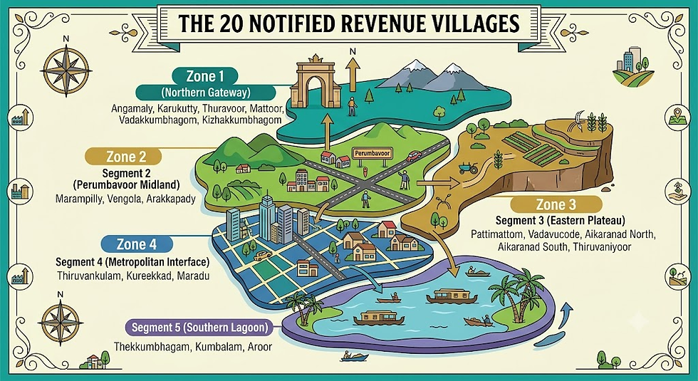
Landowners in these villages should take three immediate steps:
Audit Your Survey Records: Cross-verify your survey numbers, sub-division boundaries, and land classification (purayidam vs. nilam) in the revenue records during the ongoing field survey to ensure your title is clear.
Form Panchayat-Level Pooling Collectives: Work with local panchayats, resident associations, and farming collectives to demand that the state government pass the statutory Citizen-Equity Land Pooling Framework alongside standard NHAI acquisition.
Do Not Sell to Speculative Intermediaries: Unregulated real estate intermediaries are already attempting to acquire fragmented parcels at discounted cash rates. Retain your land title; participating as an equity shareholder ensures your family captures the long-term wealth of the corridor.
The First Kerala Model gave our families land. The Second Kerala Model must ensure we become permanent shareholders in the modern economy built upon it.
📄 Read the Complete Mathematical Blueprint: Download the full 11-section Kochi ORR Master Strategic Report (2026–2047) for the comprehensive financial tables, GIS buffer models, and draft statutory bills[cite: 1, 3]. [Download the PDF →]
Next in this series: Financing the Metropolis - How Kerala can fund a ₹26,000 Crore transit grid without adding debt to the state treasury.
Frequently Asked Questions
What is Citizen-Equity Land Pooling?
Citizen-Equity Land Pooling is an urban planning mechanism where landowners voluntarily consolidate fragmented parcels into a master-planned layout managed by a public SPV. After trunk infrastructure (roads, utilities, drainage) is constructed, landowners receive back a smaller percentage (30%–40%) of fully developed, serviced commercial/residential land in high-density nodes, alongside dividend-yielding securities, rather than a one-time cash buyout.
How does land pooling compare financially to a conventional LARR buyout?
Under a conventional LARR buyout, a landowner receives a one-time cash payment based on government fair-value registries plus statutory solatium. In land pooling, the landowner retains ownership of serviced land located inside high-density commercial hubs (FSI 8.0x–10.0x). Because serviced TOD land appreciates rapidly upon highway completion, the landowner’s forward asset value is projected to reach 2 to 3 times the initial cash compensation within 10 years.
What happens to landowners with houses on their plots?
Under the proposed statutory framework, dwelling-standing parcels convert on a superior band (40% serviced land returned + guaranteed residential plot/unit + 10% REIT units). Physical relocation is legally barred from occurring until the replacement serviced home is fully delivered, supported by a transitional living allowance.
What is the Statutory Floor-Price Guarantee?
It is a legally binding put option that protects landowners from market downturns or project delays. Enrolled landowners can exit the pooling scheme for 100% of their calculated LARR cash compensation at any point prior to physical plot delivery, providing absolute financial protection.
Why is higher FSI (8.0x–10.0x) proposed around interchanges?
High Floor Space Index (FSI) allows development to build vertically rather than sprawling horizontally. Concentrating commercial and residential space within 1.5 km of major expressway interchanges accommodates metropolitan growth while permanently protecting more than 85% of surrounding wetlands, paddy fields, and flood-attenuation basins from urban encroachment.


Comments