Why Trivandrum is Kerala’s Last Greenfield Goldmine
- Aadarsh k s
- Aug 21
- 6 min read

For decades, Kerala's economic narrative has been written almost entirely in Kochi. Endowed with early port infrastructure, a centralised geographic location, and a thriving commercial retail sector, Ernakulam naturally became the state’s commercial anchor.
But a quiet, massive spatial and infrastructural reconfiguration is underway in the south.
As Kerala looks to sustain its economic momentum, urban analysts and macroeconomic think-tanks are pointing to a harsh reality: to compete with industrial giants like Tamil Nadu and Karnataka, Kerala requires contiguous greenfield land, ultra-large logistics footprints, and heavy manufacturing hubs.
Kochi is spatially saturated. Hemmed in by backwaters, a highly congested urban grid, and an inherently shallow port draft that demands continuous capital dredging, the city simply lacks the physical capacity for this next era of heavy industrialisation because of a lack of planning and proper expansions. Civic analytics even suggest a shifting paradigm, with real estate and tourism metrics increasingly viewing Kochi as a transit bottleneck rather than a terminal destination.
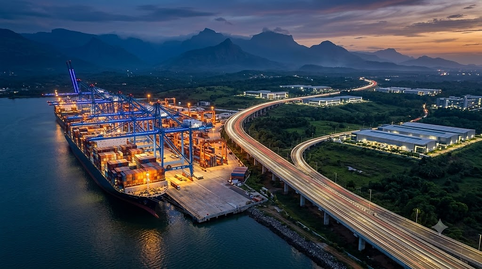
Now the Thiruvananthapuram-Kollam-Southern Tamil Nadu Mega-Corridor. Anchored by the Vizhinjam International Seaport and unlocked by transformative greenfield highways, the capital region is shedding its reputation as a quiet administrative centre to become a global logistics powerhouse.
Here is the spatial reality of Trivandrum, and why the next 20 years of Kerala's economic future belong to the South.
A Spatial Audit: Why the Outer Ring Road Defines the Future
When the government announced the ₹12,595-crore Thiruvananthapuram Outer Ring Road (ORR), designated as NH-866, laymen viewed it simply as another bypass to ease city traffic.
Urban planners view it differently. The ORR is not just a road; it is a rigid spatial boundary that dictates the economic future of the metropolitan region.

An objective spatial audit of the Thiruvananthapuram district's 2,192 sq km geography reveals severe topological and ecological constraints. Roughly 80% of the district's landmass is structurally incapable of supporting heavy, port-led industrialisation. The numbers dictate the strategy:
Protected Forests & Western Ghats (Eastern Slopes): ~1,394 sq km (63.6%)
Existing High-Density Built-Up Urban Grid: ~250 sq km (11.4%)
CRZ Wetlands, Lakes, and Rivers: ~148 sq km (6.7%)
Net Developable Greenfield Midland: ~400 sq km (18.3%)
That residual ~400 sq km is not scattered randomly. It forms a single, contiguous Midland Crescent running parallel to the coast, wrapping around the eastern edge of the existing urban grid. This crescent aligns almost perfectly with the 78-km Thiruvananthapuram Outer Ring Road and its adjoining Outer Area Growth Corridor (OAGC).
Land Classification | Area (sq km) | Share of District (%) | Spatial & Industrial Usability |
Protected Forests & Western Ghats (Eastern Slopes) | ~1,394 | 63.6% | Non-negotiable ecological buffer; zero heavy industrial zoning permitted. |
Existing Built-up Urban Core & Dense Suburbs | ~250 | 11.4% | Saturated residential/commercial fabric; cost-prohibitive land acquisition. |
CRZ Coastal Wetlands, Lakes & River Basins | ~148 | 6.7% | Strict Coastal Regulation Zone (CRZ) protection; flood buffering. |
Net Developable Greenfield Midland Crescent | ~400 | 18.3% | The entire future of Southern Kerala’s industrial & logistics expansion. |
In short: Trivandrum's last massive developable land bank and this highway corridor are the same geography. Whoever controls the zoning around this ribbon dictates the state's industrial future.
The OAGC and the Genius of Land Pooling
Built merely as a standard asphalt bypass, the ORR would trigger the same low-density, chaotic ribbon sprawl that currently chokes every arterial road in Kerala. To prevent this, the state is implementing a sophisticated "Land Pooling" framework—a masterclass in Value Capture Financing.
The OAGC is master-planned to encompass nearly 400 square kilometres, featuring eight dedicated economic clusters including logistics, IT, and health tourism. To acquire the massive 600 hectares required for the highway without causing sovereign fiscal distress or the inequitable displacement of local populations, landowners pool their parcels and transfer them to the development agency.
Corridor Segment | Primary Anchor Hubs | Master-Planned Industry Vertical | Land Pooling & Infrastructure Spec |
Northern Arc | Navaikulam, Mangalapuram, Andoorkonam | IT/ITeS, Deep-Tech, Aviation & Semiconductor Hubs | Seamless integration with Technocity, K-Space, and NH-66. |
Central Arc | Vembayam, Thekkada, Nedumangad | Precision Engineering, Agro-Food Processing & Light Manufacturing | Multi-lane elevated viaducts; bypasses urban foothill congestion. |
Southern Arc | Kattakada, Balaramapuram, Vizhinjam | Multimodal Logistics, CFS, Heavy Maritime EXIM & Bunkering | Direct interface with Port Tunnel Rail Link & IOCL logistics parks. |
Once the state builds the world-class infrastructure, individuals receive 60-70% of their holdings back. Because the land is now adjacent to a major economic corridor, the market value of that remaining 60% skyrockets exponentially. This grants owners a Minimum Assured Return, transforming a forced expropriation payout into generational wealth creation.
If your land falls within the notified villages—ranging from Navaikulam and Mangalapuram in the north (earmarked for IT and logistics) through Vembayam and Kattakada for manufacturing, down to Balaramapuram and Vizhinjam for maritime interface—your agrarian midland is slated to become a high-value Transit-Oriented Development (TOD) node.

Crucially, to mitigate ecological damage in the fragile foothills, the revised ORR alignment features an intricate network of 17 tunnels and 50 viaducts. This eliminates the destabilising hill-cutting that characterises older highway projects—a sustainable engineering pivot that recently earned a recommendation for environmental clearance from the Expert Appraisal Committee.
The Maritime Anchor: Vizhinjam’s Strategic EXIM Pivot
All of this midland development is fueled by the colossal engine sitting on the coastline. The Vizhinjam International Seaport is fundamentally distinct from any other port infrastructure in India due to its exceptional natural geomorphology: a 24-metre draft.
Port Hub | Natural Depth (Draft) | Max Vessel Capacity (TEU) | Capital / Maintenance Dredging Requirement | EXIM Gateway Competitiveness |
Vizhinjam (Trivandrum) | 24.0 Metres | 24,000+ TEU (Ultra-Large) | Zero capital dredging; negligible siltation; deep seabed 1 nautical mile from coast. | Direct mother-vessel mainline call; sub-24h transhipment turnaround. |
Kochi Port (Vallarpadam) | 14.5 Metres | ~8,000–10,000 TEU | Continuous multi-crore maintenance dredging to prevent estuarine silt buildup. | Feeder-dependent; high vessel pilotage and maintenance costs. |
Colombo (Sri Lanka) | 18.0 Metres | ~18,000–20,000 TEU | Artificial dredged basins; constant civil upkeep. | International transhipment hub; subject to geopolitical & currency volatility. |
This depth allows the port to berth ultra-large vessels exceeding 24,000 TEU capacities without the prohibitive, recurring environmental and financial costs of capital dredging. By contrast, Kochi Port requires highly expensive, continuous maintenance dredging merely to hold a depth of 14 metres.
While Vizhinjam was initially conceived primarily as a transhipment hub to compete with Colombo and Singapore, a massive macroeconomic paradigm shift has occurred. On August 18, 2026, Vizhinjam officially commenced full Export-Import (EXIM) operations. This marks its formal transition from a transhipment node into a foundational commercial gateway for domestic Indian cargo.

To capitalize on this, the state government launched Mission Samudra, an expansive maritime economic initiative backed by a ₹400-crore catalytic fund. This blueprint envisions a wider Vizhinjam Maritime Economic Region, integrating the eight-cluster industrial network, three new satellite cities, and minor ports to shift heavy cargo movement toward coastal waterways.
Plugging the Logistics Gap: The Subterranean Strategy
A historical impediment to Trivandrum’s logistical capability has been the absence of proximate Container Freight Stations (CFS) and warehousing hubs. You cannot process thousands of incoming containers daily without immediate hinterland storage.
This deficit is being aggressively remedied through state intervention. The government is acting as an industrial catalyst by repositioning state-owned land: nearly 5 acres at Trivandrum Spinning Mills in Balaramapuram have been designated for the first CFS, while another 5 acres at Kerala Automobiles Ltd (KAL) are earmarked for an empty-container yard.
Furthermore, the port company has been permitted to acquire 200 acres within a 10-km radius of the seaport. Memorandums of Understanding with the Central Warehousing Corporation (CWC) and Indian Oil Corporation (IOCL) will facilitate a ₹2,000-crore logistics master plan, delivering essential ship bunkering facilities and massive multimodal logistics parks.
But how do you move millions of tonnes of cargo from the port to these hinterland hubs without crippling the surface-level urban traffic of Thiruvananthapuram?
The answer lies underground.
Connectivity to these nodes is being secured by a highly specialised 10.7 km railway link connecting the seaport directly to the Balaramapuram railway station. Spearheaded by the Konkan Rail Corporation Ltd (KRCL) under an EPC model at an estimated cost of ₹1,482 crore, the line features a major rail tunnel—projected to be the third longest in India. This subterranean approach ensures seamless, unimpeded cargo movement that completely bypasses city roads.

The Road Ahead: The Geographical Challenge
Trivandrum now possesses the deepest port in the country, a 400 sq km land-pooled growth corridor, and underground rail links to move the cargo. The foundation is set for an economic explosion.
But moving containers to a local railhead is just the beginning. To truly eclipse neighbouring industrial states and justify a ₹3 lakh crore investment projection, this mega-corridor must push its cargo deep into the manufacturing heartlands of Tamil Nadu. It must build ultra-large ships, and it must integrate its heavy maritime industry with the bleeding-edge aerospace technology brewing in the city's north.
There is just one massive problem standing in the way of the freight: The ecologically fragile, landslide-prone, tiger-inhabited wall of the Western Ghats.

How does Trivandrum engineer a highway through a mountain without destroying it? How is the city positioning itself as India’s undisputed aerospace capital? And what will the ₹60,000-crore High-Speed Rail mean for the future of Kerala?
We will explore the ₹21,000-crore NH-744 engineering marvel, the K-Space monopoly, and the Vision 2047 roadmap in Part 2 of this series.


Comments